
Start » Filter Reference » Path » Path Spatial Transforms » PathAlongArc
 Advanced
| Module: | FoundationBasic |
|---|
Transforms a path to a coordinate system in which the 'axis' arc is vertical or horizontal.
Applications
| Name | Type | Description | |
|---|---|---|---|
 |
inPath | Path | Input path |
|
inAxis | Arc2D | Input axis arc |
|
inAxisType | Axis | Type of axis the input axis arc is parallel to |
|
inAxisCoordinate | Real | Coordinate of the axis arc |
|
inInverse | Bool | Switches to the inverse operation |
 |
outPath | Path | Transformed path |
Description
Examples
 |
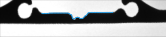 |
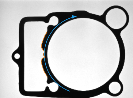
ImageAlongArc performed on the sample image with inAxisType = X and inScanWidth = 50. Blue path on output image was reprojected on original image (as orange path) using PathAlongArc with inAxisType = X, inAxisCoordinate = 25, inInverse = true. ImageAlongArc and PathAlongArc used the same arc for transformations.
Remarks
No new points are being added to input path during transformation, and this may lead to some "distortions" of path. This is especially visible on long, straight portions of input path, which are described with only 2 points: the beginning one and the ending one. After transformation, such part of path is still a line, but it may not be corresponding to the transformed image. Easy way to overcome this problem is to increase number of points creating an transformed path.
Complexity Level
This filter is available on Advanced Complexity Level.
See Also
- ImageAlongArc – Creates an image from pixels traversed along an arc.
- PointAlongArc – Transforms a point to a coordinate system in which the 'axis' arc is vertical or horizontal.
- PathAlongPath – Transforms a path to a coordinate system in which the 'axis' path is vertical or horizontal.